1/14
Soviet Military Maps Free screenshot 0
Soviet Military Maps Free screenshot 1
Soviet Military Maps Free screenshot 2
Soviet Military Maps Free screenshot 3
Soviet Military Maps Free screenshot 4
Soviet Military Maps Free screenshot 5
Soviet Military Maps Free screenshot 6
Soviet Military Maps Free screenshot 7
Soviet Military Maps Free screenshot 8
Soviet Military Maps Free screenshot 9
Soviet Military Maps Free screenshot 10
Soviet Military Maps Free screenshot 11
Soviet Military Maps Free screenshot 12
Soviet Military Maps Free screenshot 13
Soviet Military Maps Free Icon

Soviet Military Maps Free

TigerKnows
Trustable Ranking Iconယံုၾကည္ရေသာ
10K+ေဒါင္းလုဒ္မ်ား
14MBအရြယ္အစား
Android Version Icon5.1+
Android ဗားရှင်း
7.2.1 free(28-01-2024)နောက်ဆုံး ဗားရှင်း
4.5
(2 ျပန္လည္သံုးသပ္မႈမ်ား)
Age ratingPEGI-3
ထည့္သြင္းပံု
1
ထည့္သြင္းရမည့္ဖိုင္ကို ေဒါင္းလုဒ္ဆြဲကာ ဖြင့္ပါ
2
Unblock AptoideAptoide is a safe app! Just tap on More details and then on Install anyway.
3
ထည့္သြင္းမႈကို ၿပီးေအာင္လုပ္ကာ Aptoide ကိုဖြင့္ပါ
app-card-icon
အေသးစိတ္မ်ားျပန္လည္သံုးသပ္မႈမ်ားဗားရွင္းမ်ားအချက်အလက်
1/14

၏ ရွင္းလင္းခ်က္ Soviet Military Maps Free

Offroad Navigation App with worldwide topographic maps (mainly Russian General Staff). For many countries in Africa and Asia these maps still belong to the best available topomaps.


Available map layers:

• Topomaps worldwide (worldwide seamless coverage, mainly 1:100.000)

• ROSREESTR The Federal Service for State Registration, Cadastre and Cartography

• Google Maps (Satellite images, Road- and Terrain-Map)

• Open Street Maps (OSM Mapnik, Osmarender and Cloudemade Cyclemap)

• Bing Maps

• ESRI Maps


This app gives you similar mapping options as you might know from Garmin or Magellan GPS handhelds.


Main features for Outdoor-Navigation:

• Create and edit Waypoints

• GoTo-Waypoint-Navigation

• Track Recording (with speed and elevation profile)

• Tripmaster with fields for odometer, average speed, bearing, elevation, etc.

• GPX,KML - Import

• Search (placenames, POIs, streets)

• Customizable datafields in Map View and Tripmaster (e.g. Speed, Distance, Compass, ...)

• Bulk-download of map tiles for OFFLINE USAGE (NOT in free version)

• Импорт Oziexplorer map format in OZF2 OZFX3 extension (NOT in free version)

• Импорт OpenStreetMaps in vector format (NOT in free version)

• Waypoint-/Track-Sharing (via eMail, Facebook, ..)

• and many more ...


Soviet Military Maps is the perfect moving map app for offroad trips, adventure travels and expeditions. You are planning cross country trips to Sahara desert or a trekking tour to the Himalayas ? With the Russian topos you have always a great alternative to other map sources. Beneath the good topography the maps include many small trails and unpaved roads that are missing in other map sets.

The Russian maps have additional English labels.

Attention: The Soviet Military Maps were created mainly in the 80ies and are less interesting for industrialized countries. Outside Africa and Asia you'll find the OSM / Google map layers more useful.

Please note: This app does not provide direct "Turn-by-Turn" navigation - but with a selected waypoint you can easily switch to Google Navigation.


LIMITATIONS OF THE FREE VERSION:

• Ads

• Max. 3 Waypoints

• Max. 3 Tracks

• No import of waypoints and tracks

• No Bulkdownload

• No Local City DB (Offline Search)

• No Hillshading Overlay


Please contact us if you have any questions, feature requests or bug reports regarding this app: android@atlogis.com


Map coverage:

Scale 1:100.000 and 1:200.000 :

Europe, Afghanistan, Azerbaijan, Georgia, Japan, Jordan, Latvia, Lithuania, Kazakhstan, Kyrgyzstan, Morocco, Mongolia, Pakistan, Russia, Syria, Tajikistan, Turkey, Turkmenistan, Ukraine, Uzbekistan, Belarus


Scale 1:200.000 :

Afghanistan, Egypt, Algeria, Angola, Argentina, Armenia, Azerbaijan, Bahrain, Bangladesh, Belarus, Benin, Bhutan, Bolivia, Botswana, British Virgin Islands, Bulgaria, Burkina Faso, Burma, Cambodia, Cameroon, Central African Republic, Chad, Chile, China, Comoros, Ivory Coast, Cuba, Cyprus, Czech Republic, DR Congo (part), Djibouti, Eritrea, Estonia, Ethiopia, Falkland Islands, Finland, Gambia, Georgia, Ghana, Guinea, Guinea-Bissau, Iceland, India, Indonesia, Iran, Iraq, Israel, Jamaica, Jordan, Kazakhstan, Kenya (part), Kuwait, Kyrgyzstan, Laos, Latvia, Lebanon, Lesotho, Liberia, Libya, Lithuania, Madagascar, Malawi, Malaysia, Mali, Mauritania, Moldova, Mongolia , Morocco, Mozambique, Namibia, Nepal, Niger, Nigeria, North Korea, Oman, Pakistan, Philippines, Qatar, Romania, Russia, Saudi Arabia, Senegal, Sierra Leone, Singapore, Slovakia, Somalia, South Africa, South Korea, Spain, Sri Lanka , Sudan, Svalbard, Swaziland, Sweden, Syria, Taiwan, Tajikistan, Tanzania (part), Thailand, The Gambia, Togo, Tunisia, Turkey, Turkmenistan, Ukraine, United Arab Emirates, Uzbekistan, Vietnam, Western Sahara, Yemen, Zambia, Zimbabwe


Scale 1:250.000 (Local maps from USGS, Geoscience Australia, CTIO ):

USA, Canada, Australia


Scale 1:500.000:

All other countries

ကမ္ဘာတစ်ဝှမ်းတွင်မြေမျက်နှာသွင်ပြင်မြေပုံ (အဓိကအားဖြင့်ရုရှားအထွေထွေဝန်ထမ်း) တစ်ခုနဲ့အစားထိုးခဲ့တယ် Navigation App ကို။ အာဖရိကနှင့်အာရှရှိနိုင်ငံအများအပြားအတွက်ဤမြေပုံနေဆဲအကောင်းဆုံးရရှိနိုင် topomaps ပိုင်။


ရရှိနိုင်ပါမြေပုံအလွှာ:

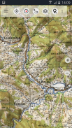
ကမ္ဘာတစ်ဝှမ်း• Topomaps (ကမ္ဘာတစ်ဝှမ်းတွင်ချောမွေ့စွာလွှမ်းခြုံ, အဓိကအားဖြင့် 1: 100.000)

• ROSREESTR အဆိုပါဖက်ဒရယ်ပြည်နယ်မှတ်ပုံတင်ခြင်းများအတွက်ဝန်ဆောင်မှု, Cadastre နှင့် Cartography

• Google Maps ကို (ဂြိုဟ်တုပုံများ, Road- နှင့်မြေမျက်နှာသွင်ပြင်-မြေပုံ)

•ပွင့်လင်း Street, Maps ကို (OSM Mapnik, Osmarender နှင့် Cloudemade Cyclemap)

• Bing မြေပုံ

• ESRI Maps ကို


သငျသညျ Garmin သို့မဟုတ်မက်ဂျလန်ဂျီပီအက်စ်လက်ကိုင်ကနေကိုသိစေခြင်းငှါ, အဖြစ်ဒီ app ကိုသင်အလားတူမြေပုံ options များပေးသည်။


အဆောက်အဦးအပြင်-Navigation များအတွက်အဓိကအင်္ဂါရပ်များ:

•အမှတ်များ ဖန်တီး. တည်းဖြတ်

• Goto-အမှတ်-Navigation

• (အမြန်နှုန်းနှင့်မြင့်ကိုယ်ရေးအကျဉ်းကိုနှင့်အတူ) Track ကိုမှတ်တမ်းတင်ရန်

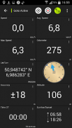
•စသည်တို့ကို odometer ပျမ်းမျှအမြန်နှုန်း, bearing, မြင့်များအတွက်လယ်ကွင်းတွေနဲ့ Tripmaster

• GPX, KML - သွင်းကုန်

•ရှာရန် (PLACENAME, မှန်မှန်, လမ်းများ)

မြေပုံကြည့်ရန်နှင့် Tripmaster (ဥပမာမြန်နှုန်း, အဝေးသင်, သံလိုက်အိမ်မြှောင်, ... ) ထဲမှာ•စိတ်ကြိုက် datafields

• (မအခမဲ့ဗားရှင်း) အော့ဖ်လိုင်းအသုံးပြုမှုများအတွက်မြေပုံကွက်များအစုလိုက်-download,

• (မအခမဲ့ဗားရှင်း) OZF2 OZFX3 extension ကိုအတွက်Импорт Oziexplorer မြေပုံပုံစံ

•အားနည်းချက်ကို format နဲ့Импорт OpenStreetMap (မဟုတ်ပါအခမဲ့ဗားရှင်း)

• Waypoint- / Track-မျှဝေခြင်း (အီးမေးလ်ကနေတဆင့် Facebook က .. )

•အများအပြားကပို ...


ဆိုဗီယက်စစ်တပ် Maps ကို offroad ခရီးစဉ်, စွန့်စားမှုခရီးသွားမှတ်တမ်းနှင့်လေ့လာရေးခရီးသွားများအတွက်စုံလင်သောရွေ့လျားမြေပုံ App ဖြစ်ပါတယ်။ သငျသညျလက်ဝါးကပ်တိုင်တိုင်းပြည်ဟိမဝန္တာမှဆာဟာရသဲကန္တာရသို့မဟုတ်တစ်တောင်တက်ခရီးစဉ်မှ trips စီစဉ်နေကြသနည်း ရုရှား topos နှင့်အတူသင်အမြဲကတခြားမြေပုံသတင်းရင်းမြစ်တစ်ခုအကြီးအကအခြားရွေးချယ်စရာရှိသည်။ ကောင်းမွန်သောမြေမျက်နှာသွင်ပြင်ကိုလည်းငုံ့မြေပုံများစွာကိုသေးငယ်တဲ့လမ်းကြောင်းနှင့်အခြားမြေပုံအစုံအတွက်ပျောက်ဆုံးနေပါတယ်လူတွေမှာလမ်းများပါဝင်သည်။

ရုရှားမြေပုံများအားအပိုဆောင်းအင်္ဂလိပ်တံဆိပ်များရှိသည်။

အာရုံစူးစိုက်မှု: အဆိုပါဆိုဗီယက်စစ်တပ် Maps ကိုပု 80ies အတွက်အဓိကအားဖြင့်ဖန်တီးခဲ့သည်နှင့်စက်မှုနိုင်ငံများအတွက်လျော့နည်းစိတ်ဝင်စားဖို့များမှာခဲ့ကြသည်။ အာဖရိကနှင့်အာရှအပြင်ဘက်တွင်သင်ပိုမိုအသုံးဝင်သောအဆိုပါ OSM / Google ကမြေပုံအလွှာကိုရှာဖွေပါလိမ့်မယ်။

ကျေးဇူးပြု. သတိပြုပါ: ဒီ app ကိုတိုက်ရိုက် "Turn-by-ပြန်လာ" အညွှန်းမပေးပါဘူး - ဒါပေမယ့်တစ်ဦးကိုရွေးချယ်အမှတ်များနှင့်အတူသင်အလွယ်တကူ Google က Navigation ပြောင်းနိုင်ပါသည်။


အခမဲ့ဗားရှင်း Limited:

•ကြော်ငြာ

•မက်စ်။ 3 အမှတ်များ

•မက်စ်။ 3 သီချင်းများ

•အမှတ်များနှင့်အပုဒ်၏အဘယ်သူမျှမတင်သွင်း

•အဘယ်သူမျှမ Bulkdownload

•အဘယ်သူမျှမဒေသခံစီးတီး DB (အော့ဖ်လိုင်းဖြင့်ရှာရန်)

•အဘယ်သူမျှမ Hillshading Overlay ကို


သငျသညျဒီ app နှင့်ပတ်သက်သည့်မည်သည့်မေးခွန်းများကို, အင်္ဂါရပ် requests သို့မဟုတ် bug ကိုအစီရင်ခံစာများရှိပါကကျွန်တော်တို့ကိုဆက်သွယ်ပါ: android@atlogis.com


မြေပုံလွှမ်းခြုံ:

စကေး ​​1: 100,000 နှင့် 1: 200,000:

ဥရောပ, အာဖဂန်နစ္စတန်, အဇာဘိုင်ဂျန်, ဂျော်ဂျီယာ, ဂျပန်, ဂျော်ဒန်, လတ်ဗီးယား, လစ်သူ, ကာဇက်စတန်, ကာဂျစ္စတန်, မော်ရိုကို, မွန်ဂိုလီးယား, ပါကစ္စတန်, ရုရှား, ဆီးရီးယား, Tajikistan, တူရကီ, တာ့ခ်မင်နစ္စတန်, ယူကရိန်း, ဥဇဘက်, ဘီလာရုစ်


စကေး ​​1: 200,000:

အာဖဂန်နစ္စတန်, အီဂျစ်, အယ်လ်ဂျီးရီးယား, အင်ဂိုလာ, အာဂျင်တီးနား, အာမေးနီးယား, အဇာဘိုင်ဂျန်, ဘာရိန်း, ဘင်္ဂလားဒေ့ရှ်, ဘီလာရုစ်, ဘီနင်, ဘူတန်, ဘိုလီးဗီးယား, ဘော့ဆွာနာ, British Virgin Islands, ဘူလ်ဂေးရီးယား, Burkina Faso, မြန်မာ, ကမ္ဘောဒီးယား, ကင်မရွန်း, ဗဟိုအာဖရိကသမ္မတနိုင်ငံ, ချဒ်, ချီလီ , တရုတ်, ကော်မ္မရိုဇ့်, အိုင်ဗရီကို့စ်, ကျူးဘား, ဆိုက်ပရပ်စ်, ချက်သမ္မတနိုင်ငံ, ကွန်ဂို (အပိုင်း), ဂျီဘူတီနိုင်ငံ, အီရစ်ထရီးယား, စတိုးနီးယား, အီသီယိုးပီး, ဖောက်ကလန်ကျွန်းစု, ဖင်လန်, ဂမ်ဘီယာ, ဂျော်ဂျီယာ, ဂါနာ, ဂီနီ, ဂီနီဘစ်, အိုက်စလန်, အိန္ဒိယ, အင်ဒိုနီးရှား, အီရန်, အီရတ်, အစ္စရေး, ဂျမေကာ, ဂျော်ဒန်, ကာဇက်စတန်, ကင်ညာ (အပိုင်း), ကူဝိတ်, ကာဂျစ္စတန်, လာအို, လတ်ဗီးယား, လက်ဘနွန်, လီဆိုသို, လိုက်ဘေးရီးယား, လစ်ဗျား, လစ်သူ, ဒါဂတ်စကာ, မာလာဝီ, မလေးရှား, မာလီ, Mauritania, မော်လ်ဒိုဗာ, မွန်ဂိုလီးယား , မော်ရိုကို, မိုဇမ်ဘစ်, နမီးဘီးယား, နီပေါ, နိုင်ဂျာ, နိုင်ဂျီးရီးယား, မြောက်ကိုရီးယား, အိုမန်, ပါကစ္စတန်, ဖိလစ်ပိုင်, ကာတာနိုင်ငံ, ရိုမေးနီးယား, ရုရှား, ဆော်ဒီအာရေဗျ, ဆီနီဂေါ, ဆီယာရာလီယွန်, စင်္ကာပူ, Slovakia ဆိုမာလီယာ, တောင်အာဖရိက, တောင်ကိုရီးယား, စပိန်, သီရိလင်္ကာနိုင်ငံ, ဆူဒန်, Svalbard, ဆွာဇီလန်, ဆွီဒင်, ဆီးရီးယား, ထိုင်ဝမ်, Tajikistan, တန်ဇန်းနီးယား (အစိတ်အပိုင်း), ထိုင်း, အဆိုပါ Ga mbia, တိုဂို, တူနီးရှား, တူရကီ, တာ့ခ်မင်နစ္စတန်, ယူကရိန်း, အာရပ်စော်ဘွားများပြည်ထောင်စု, ဥဇဘက်, ဗီယက်နမ်, အနောကျပိုငျးဆာဟာရ, ယီမင်, ဇမ်ဘီယာ, ဇင်ဘာဘွေ


စကေး ​​1: 250.000 (USGS ကနေဒေသခံမြေပုံများ, Geoscience သြစတြေးလျ, CTIO):

အမေရိကန်, ကနေဒါ, သြစတြေးလျ


စကေး ​​1: 500,000:

အားလုံးအခြားနိုင်ငံများ


Soviet Military Maps Free - ဗားရွင္း 7.2.1 free

(28-01-2024)
အျခား ဗားရွင္းမ်ား
ဘာအသစ္ရွိလဲ• Improvements & Fixes

သုံးသပ္ခ်က္ သို႔မဟုတ္ အဆင့္သတ္မွတ္ခ်က္မ်ား မရွိေသးပါ။ ပထမဆုံး ျပဳလုပ္ရန္အတြက္ ကို ထည့္သြင္းေပးပါ။

-
2 Reviews
5
4
3
2
1
Info Trust Icon
ေကာင္းမြန္ေသာအက္ပ္ျဖစ္ေၾကာင္း အာမခံသည္ဤအက္ပ္သည္ ဗိုင္းရပ္စ္၊ ေမးလ္၀ဲႏွင့္ အျခားမသမာေသာ တိုက္ခိုက္မႈမ်ားအတြက္ လံုၿခံဳေရးစစ္ေဆးခ်က္ကို ေအာင္ျမင္ခဲ့ၿပီး မည္သည့္အႏၲရာယ္မွ် မရွိပါ။

Soviet Military Maps Free - APK သတင္းအခ်က္အလက္

APK ဗားရွင္း: 7.2.1 freepackage: com.atlogis.sovietmaps.free
အန္းဒ႐ိုက္ ကိုက္ညီမႈ: 5.1+ (Lollipop)
ထုတ္လုပ္သူ:TigerKnowsကိုယ္ေရးလံုၿခံဳမႈ မူ၀ါဒ:http://www.atlogis.com/Atlogis_Privacy_Policy.pdfခြင့္ျပဳခ်က္မ်ား:20
အမည္: Soviet Military Maps Freeအရြယ္အစား: 14 MBေဒါင္းလုဒ္မ်ား: 3Kဗားရွင္း : 7.2.1 freeျဖန္႔ခ်ိသည့္ ရက္စြဲ: 2024-03-12 11:23:29စခရင္အေသး: SMALLအေထာက္အပံ့ေပးနိုင္ေသာ စီပီယူ:
ပက္ေက့ဂ်္အိုင္ဒီ: com.atlogis.sovietmaps.freeSHA1 လက္မွတ္: D8:C6:8E:17:4B:AE:BE:EC:B8:F7:8C:E9:6D:07:66:55:4D:D0:F8:5Cထုတ္လုပ္သူ (CN): Atlogis Geoinformatics oHGအဖြဲ႕အစည္း (O): Atlogis Geoinformatics oHGေဒသဆိုင္ရာ (L): G√ºterslohနိုင္ငံ (C): DEျပည္နယ္/ၿမိဳ႕ေတာ္ (ST): NRW

Soviet Military Maps Free ၏ ေနာက္ဆုံးဗားရွင္း

7.2.1 freeTrust Icon Versions
28/1/2024
3K ေဒါင္းလုဒ္မ်ား13.5 MB အရြယ္အစား

အျခား ဗားရွင္းမ်ား

7.1.1 freeTrust Icon Versions
23/11/2023
3K ေဒါင္းလုဒ္မ်ား14.5 MB အရြယ္အစား
7.1.0 freeTrust Icon Versions
26/10/2023
3K ေဒါင္းလုဒ္မ်ား11 MB အရြယ္အစား
7.0.4 freeTrust Icon Versions
24/8/2023
3K ေဒါင္းလုဒ္မ်ား11 MB အရြယ္အစား
7.0.3 freeTrust Icon Versions
21/7/2023
3K ေဒါင္းလုဒ္မ်ား11 MB အရြယ္အစား
7.0.0 freeTrust Icon Versions
24/3/2023
3K ေဒါင္းလုဒ္မ်ား11 MB အရြယ္အစား
6.9.1 freeTrust Icon Versions
19/1/2023
3K ေဒါင္းလုဒ္မ်ား10.5 MB အရြယ္အစား
6.9.0 freeTrust Icon Versions
11/1/2023
3K ေဒါင္းလုဒ္မ်ား10.5 MB အရြယ္အစား
6.8.0 freeTrust Icon Versions
12/7/2022
3K ေဒါင္းလုဒ္မ်ား11 MB အရြယ္အစား
6.7.2 freeTrust Icon Versions
24/3/2022
3K ေဒါင္းလုဒ္မ်ား11 MB အရြယ္အစား

က႑တူအက္ပ္မ်ား

သင္ႏွစ္သက္ႏိုင္သည္မ်ားမွာ...